
Finally, I have completed the Great North Walk ‘through hike’ that gives this website its name, the GNW250!
GNW250 “through hike” September 2015
The Great North Walk is a bush track between Sydney and Newcastle. Officially it is 250km, but in reality is more like 275km or 260km, depending on which route you take over the Hawkwsbury River. The longer route from Brooklyn to Patonga requires either a long drive or a boat. The alternative is a train from Brooklyn (Hawkesbury River station) to Wondabyne. For this walk I took the train. Regardless of the exact distance end-to-end “through hikes” are generically called “GNW250”.
My GNW250 was a solo, self-supported bushwalk. I didn’t try to run, didn’t have a crew of people helping me, and didn’t have “pacers” walking with me. I did leave two supply drops along the way to save having to carry everything for such a long walk. I did the GNW250 because it had long been an ambition of mine to do it as a personal challenge. In 2012 I tried it and failed. This time I succeeded, finishing in about 4 ¼ days. A report follows.
1. Preparations for the Great North Walk “through hike”
I train a lot for long race walks and bushwalks as part of my weekly routine, as a matter of course. In preparation for this GNW250 I refrained from entering any races so I could focus on this goal. I included lots of long bushwalks in my training as well as various long road walks, the longest being 84km, but with a fair few above 50km. About five weeks before this GNW250 I got sick and couldn’t train much, and then three weeks before I injured my left ankle somehow (in bed!) and did almost no training at all. The enforced rest was probably helpful.
The walk was due to start in the morning of Saturday 26 November from Newcastle. Extravagantly, I flew from Sydney to Newcastle the Thursday night before after work. I had a late-finishing meeting with Karl, my PhD supervisor at Sydney Uni and a 6:30pm flight. Wet weather, traffic.. arrived at the airport at 6:05pm, convinced I was too late. Luckily the nice people at REX still let me check in. As I walked through security they were calling my name as a final call for boarding. Moments later I was on the plane for the 20-minute flight to NTL where my bag, last on, was first off. I hired a car so that the next day I could drive to Watagan Ck Rd to leave one of my supply drops. It also turned out to be handy for driving around doing last-minute shopping for things I’d left at home, like shorts and bodyglide (anti-chafing lube).
Flying costs a lot more than the train, but was so much quicker and cost less than driving (in my car at least).
2. Leg 1 Queens Wharf, Newcastle, to Barraba Trig campsite, 68km.
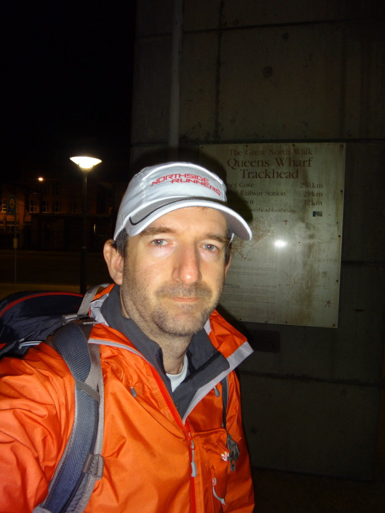 After a quick start line photo I left Queen’s Wharf, the Newcastle end of the walk at 4:15am, about an hour before first light. The first part of the walk moves quickly past the Newcastle beaches along streets until it reaches Mereweather Baths. There the trail follows the sand to Burwood Beach and Glenrock lagoon. Unfortunately it was high tide and quite stormy, making it too dangerous to walk along the shore around the rocky headland. I was forced into a long and steep detour up and over the headland before re-joining the track at Glenrock.
I made reasonable but not fast time to Warners Bay and then Teralba where I had a 10am coffee stop at a weird place that seemed more like someone’s living room than a coffee shop. The coffee was good.
By about 1:00 I was at the service station in Heaton Gap where I stopped for lunch. I had hot chips, a serve so massive I couldn’t finish it. I filled up all my water containers as, in the past, water had been unreliable up on the ridge tops of the Watagans. Suddenly my pack was about 3.5kg heavier than before, just before the serious climb up to Heaton lookout. It was an unpleasant shock to the system. It also turned out that I needn’t have carried nearly so much: water was plentiful in creeks each time the track dropped down into the valleys and also many of the campsites had brand new water tanks installed.
It got dark as I made my way through the third and final rainforest section before Watagan Forest HQ camping area. The track through the rainforest is pretty sketchy and hard to follow. There was good water in each rainforest gully.
My first day ended at 10:38pm at Barraba Trig campsite, 68km. This was actually about 20km short of my target for the day, but is was late and I was very sleepy. My rough plan was walk 20 hours, rest 4 with a target of 80km each day. This was unrealistic and I should have taken terrain into account for the planning. As I was travelling light I didn’t have any sleeping bag or tent with me. I had some warmer sleeping gear in my first stash at Watagan Ck Rd, but that was still 20km away. My sleep was fitful and very cold. I had a garbage bag full of leaves as insulation from the cold ground and an emergency “space” blanket to wrap up in. I wore thermals, a fleece, a buff, and waterproof jacket and pants to help defeat the wind and as extra warmth. It was still cold.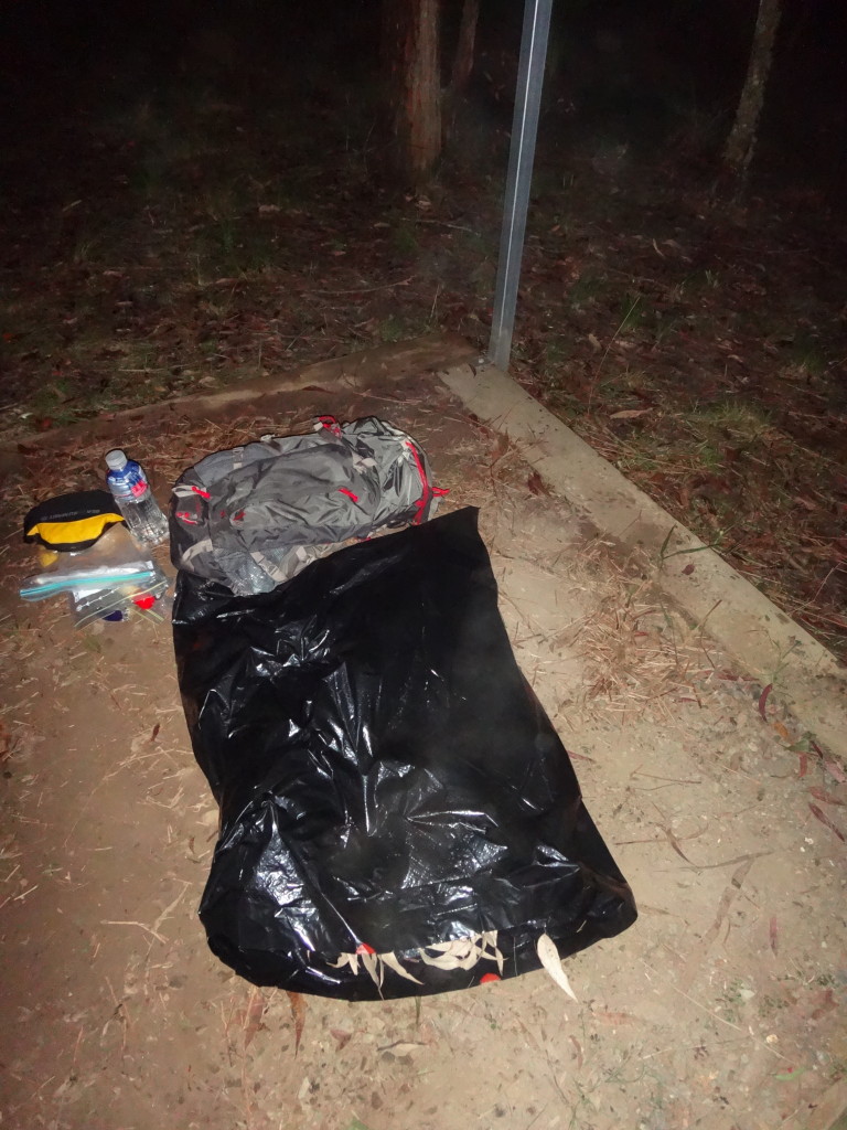
Leg 2: Barraba Trig to Yarramalong, 58km.
I started again just after 4am feeling much fresher even after so little sleep. I got down the steep hill to Congewai Valley rd in the early morning light and made good time along the gently undulating country road. I saw a few people and lots of noisy cows, plus a few horses that seemed suspicious of me. After a while the road seemed to have been going on too long, so I checked my map to see how much further before the turn off might be. I got so engrossed in reading the map that I walked right past the turn off. When I hit a paved section of road, I realised that it was beyond the turnoff on the map, so backtracked. Off Congewai Rd the Great North Walk track goes through some private land and then very steeply up a rough track to an old radio tower on the ridgetop. I reached that spot at 9:24am.
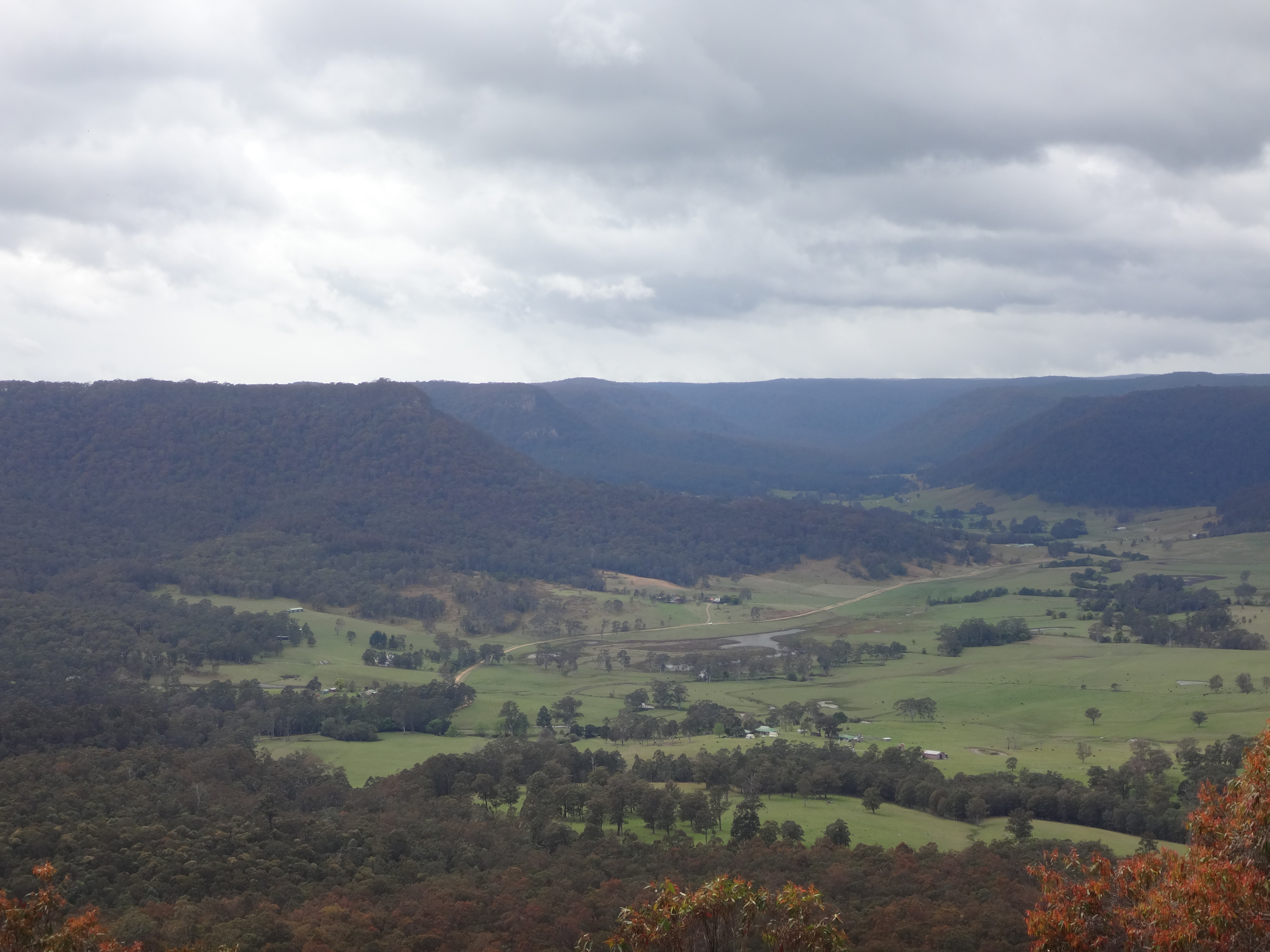
At 10:30 I paused for photos at Flat Rock lookout, which has great views over the Congewai Valley ( I think). A few minutes after that I passed a walkers rest area which had a new water tank. The campsite was in a pretty disgusting state, probably because it is accessible to cars. People who drive to campsites seem to leave lots more garbage than walkers, even though it is so much easier for drivers to carry it out with them. In my experience, campsites accessible to cars are always in a worse state than more remote ones.
 I arrived at Watagan Ck rest area at 11:43am. I retrieved my supply drop and rested for about an hour, eating a big lunch. I picked up a new emergency blanket, a warm puffy jacket for that night, and some food and water. Then it was off up the steep climb back to the ridges high above. The climb seemed much shorter than I remembered, about the only bit of the walk that did seem shorter than in my memory. My memory of the walk consisted of lots of landmarks but the long stretches joining them together were glossed over. The Great North Walk does involve many interminable stretches of fire trail and road. If I was doing the walk at a slower pace and just for pleasure, I’m sure they’d seem much nicer.
As I approached the rainforest near the Basin campsite, I discovered a whole other rainforest valley that I’d completely forgotten about, followed by another interminable fire trail before the rainforest I remembered. I eventually got to the walkers rest area above Cedar Brush Ck just as darkness fell, so about 6pm. There was another walker camping there, only the second walker I had seen since Newcastle. He was walking from Wondabyne to Teralba. Foolishly I boasted to him that I dreamed of reaching as far as Mooney Mooney by the early hours of the next morning, which was true. But my hubris ensured that I only got as far as Yarramalong instead, putting an end to my hopes of completing the walk on the third day.
I left the camper to his dinner and continued down to the Cedar Brush trackhead, arriving there at 7:10pm. From there it was 11 painful km along the paved road to the village of Yarramalong. I got slower and slower along this stretch and decided I probably needed somewhere to camp. The problem is, that would involve a dry camp site somewhere on the hill above the village. But I was running out of water. I knew that there was no water tap available in Yarramaolong, so what to do?
I also knew that Yarramalong has a primary school in it, and surely a school would have a tap. So I walked on, beyond the normal turn off, and extra few hundred metres to the school. After a bit of a hunt and dodging various sensor-operated security lights, I found a tap. I decided it was silly to keep going that night, so I decided to camp in the school grounds. Unfortunately for me their excellent security precautions meant that various warm, wooded-floored veranda areas were off-limits. A patch of long-but-damp grass was my best option.
With the addition of my puffy jacket and an extra plastic sheet (a drop sheet from Bunnings), I was much warmer that nights, though still chilly and regretting having brought no gloves. I slept 6 hours and set off at 4am. Hopefully no one saw me trespassing in the school, but they probably did. One thing I know about walking along quiet country roads is that, despite the apparent solitude, someone is ALWAYS watching you and people know where you are and what you are doing all the time. Country people watch, and they tell each other the details too. At least no one called the police.
Leg 3: Yarramalong to Piles Ck, 49km
I left Yarramalong school at 4am for my “easy” day, the highlight of which was surely to be a hot meal at the Somersby general store. It was cold and I was stiff and sore, so getting going was hard and I made slow progress up Bumble Hill out of Yarramalong village. At about 6:30am I reached the top. There was another short road section along Cherry Lane before more single-track trough a varied landscape of sandstone ridge top, dry forest, and deep rainforest gully. Next came a stretch of fire trail along Tooheys Rd that ended in a steep track down Stringybark Point and into the Ourimbah Valley. On my previous GNW250 attempt I was in real trouble by this point and it took me a whole day to get from here back to Yarramalong. This time I was here by 9:40am, a still relatively leisurely 5 hours but much better. Finishing the walk this time was not in doubt, at any time. It was just a matter of how long it would take.
Ourimbah Valley was the only place I saw any snakes during the walk, a couple of Black Snakes. One slithered away from the track in the bush of Stringybark Point. I stopped to wait while the second one crossed the road in front of my just near the Hidden Valley riding farm. I also passed a lady walking a gigantic horse along this road.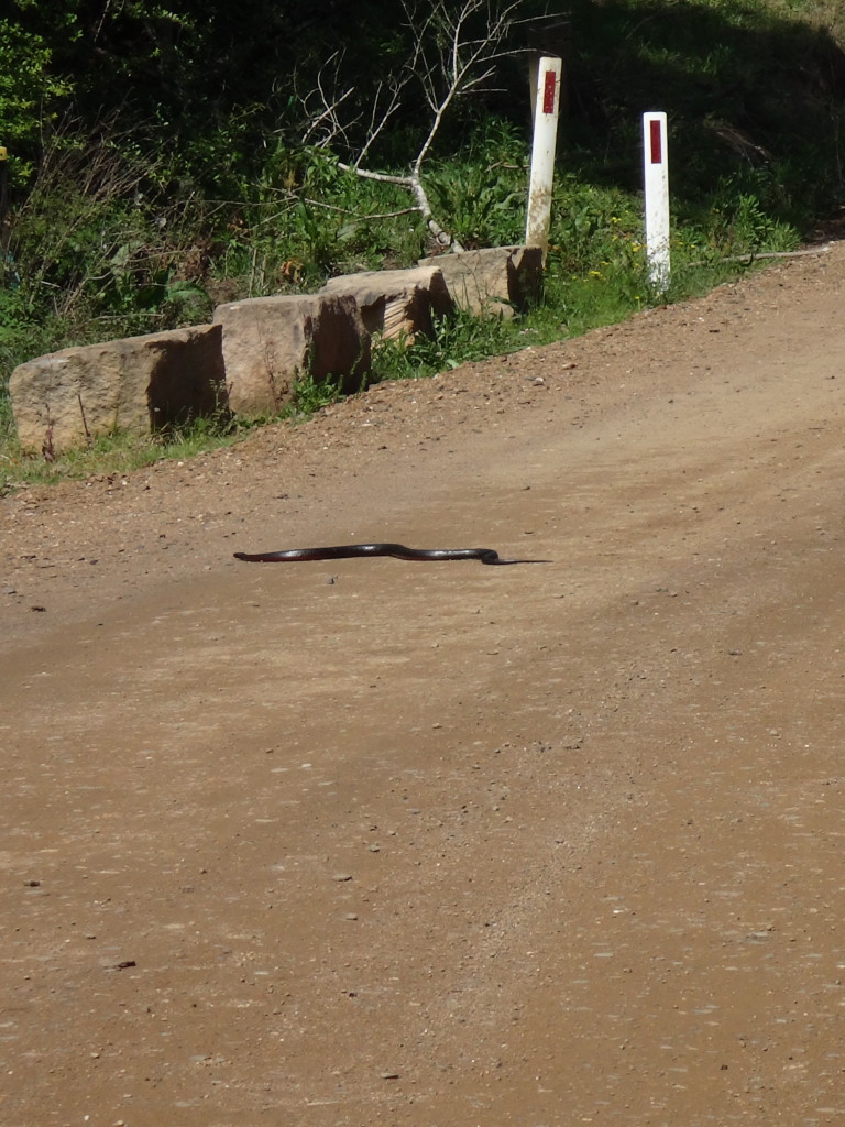
11:30am saw me starting the climb up into the little Palm Grove National Park which involves a steep climb up, then a plunge down into beautiful rainforest, then another steep climb up and out before emerging in the back streets of the Central Coast village of Somersby. It was a treat to walk through here in daylight and not to encounter any dangerous dogs, for which this little stretch is notorious.
I got to the Somersby store just before 2pm and enjoyed a burger and chips for lunch. The calories were very welcome. I stayed for an hour, and met a father and son who’d just camped at Piles Ck the night before. They hadn’t found my stash, though it was very well hidden and I’d be surprised if it was found. At 2:50 I set off slowly for Piles Ck where I would camp for the night. Normally it would be about 2 hours. That afternoon it took me about 5 hours – I was starting to slow down.
Just out of Somersby and before the descent down to Mooney Mooney Ck, I came across a little pack of wild dogs. I don’t know what breed they were, but they were short and squat, some were black and some were white. They were not aggressive and ran down the track ahead of me for a while, like bush turkeys do, before scattering into the bush. Later, however, alongside Mooney Mooney Ck I was menaced by a similar-looking black dog that growled and barked softly in the darkness. I don’t know if it was wild or domestic, because it was near the houses there and stalked me for a while but then seemed to disappear up the track to one of the houses. I did pick up a hefty stick for protection however and was quite prepared to kill the nasty thing should it actually attack.
At 7:32pm I was crossing the Old Pacific Highway at Mooney Mooney Ck, and half an hour later was at the Piles Ck campsite. There was no one else there and I retrieved my final stash and settled in for a luxuriously long night, this time 10 hours of rest all up. I had even better sleeping gear at this camp, with a ¼ thermarest, a heavy tarp, and a ½ fleece ½ waterproof vinyl picnic blanket. It was a chilly and dry night, but I slept comfortably.
Leg 4: Piles Ck to Sydney Cove, 90km. Finishing the Great North Walk!
I left camp at 6:45am and got to Wondabyne station in time for the 9:17am train to Hawkesbury River station at Brooklyn. I had no more stops planned: this was to be a final big push to the end, however long it might take. I figured that motivation from being so close to home plus the familiarity of landmarks along the way would help I was partly right. It was still long and hard going.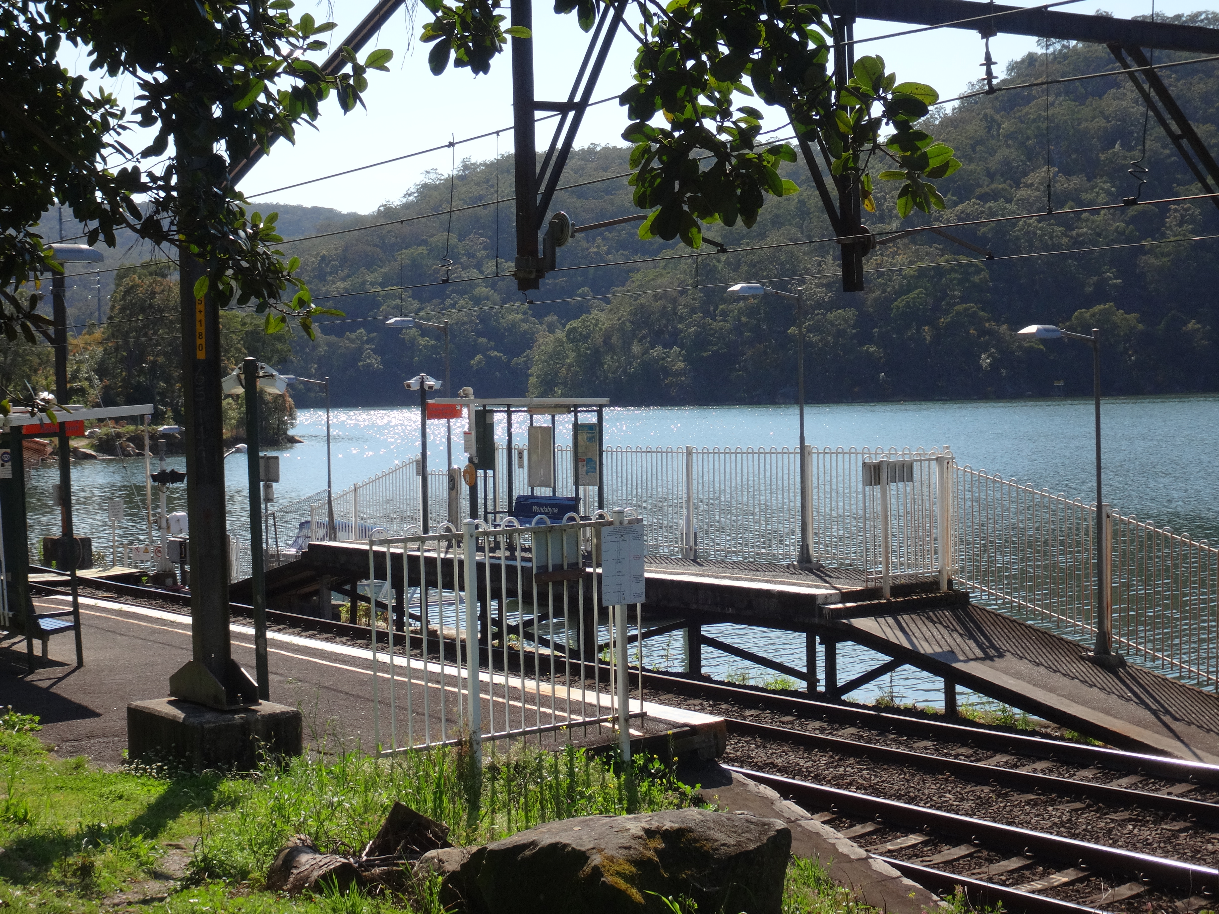
Wondabyne is a tiny platform in the bush by a branch of the Hwakesbury river. Some trains will stop there, but you have to hail the driver, like at a bus stop. It stops and the last door of the last carriage opens to let you in. If you want to get off there you have to travel in the last carriage and tell the guard you want the train to stop. A couple of people live in river-access-only houses near there and park their dinghies at an adjacent jetty. Otherwise Wondabyne is used by bushwalkers. It provides the best access over the Hawkesbury for anyone doing the Great North Walk, but does cut out about 15km of track to Patonga. Unfortunately getting from Patonga to Brooklyn is not easy. There used to be a ferry, but not for many years.
I was leaving Brooklyn by around 10:00 having bought some food at the over-priced general store. It is one of those old-school mixed business shops where the proprietors seem a bit put out that anyone would dare enter, glare at you suspiciously, are a bit surly, and charge inflated prices. I guess because of where they are, they can.
It took 3 ½ hours to walk to Cowan, not too bad, but still quite slow for me. I passed three massive groups of Duke Of Edinburgh students on this very popular stretch of the Great North Walk. Have to say that the hiking part of that, at least, seems like a pretty watered-down farce leading to a meaningless and pointless “qualification”.
I stopped at Cowan to buy some drinks some final food supplies at the somewhat friendlier general store. By 2:25 I was back on the trail having paused to digest my lunch and rest a bit in the sun. I was starting to have trouble regulating my body temperature by this point. Moving, I felt overheated, but the moment I stopped I was cold, even shivering.
4:30 I stopped to use the very clean public toilet at Berowra Waters, the roughest part of the walk now behind me. The track from Brooklyn to Berowra Waters is the roughest of the whole Great North Walk, with very slow and hard going. There are some rough bits on the climb out of Berowra Waters too, but not so bad. I was approaching Calna Creek, below Berowra and Mt Kuringai as night fell. This night I was not stopping, but walking right through.
I stopped briefly for a bite to eat at Crosslands camping area just after 7pm. It was pretty dreadful there: at least two giant groups of teens yahooing and drinking. I’m pretty sure they were there with organised private Duke of Ed groups. One big groups was around a fire, but they were slipping away to drink. Sure, that what teenagers do, but don’t give them a “gold award” for doing it! In any case, unless you are there to party too, I’d advise against camping at Crosslands.
 From Crosslands my camera began warning of no battery left, so I had to stop taking so many pictures and am less clear on what times I was where, as the photos show the time they were taken. Of course the flat camera battery also increased my risk of encountering a Yowie or a UFO. I made slow but steady progress up the long Galston Gorge. First it is flat walking along the river banks through damp woodland, pretty by day and a bit sinister by night. Under the bridge where the road crosses the Gorge, with roaring cars racing up and down, and then over the last big climb of the Great North Walk, past Tunks Ridge campsite, over Steele Bridge, past Fishponds underneath Hornsby, then up to the Westleigh cliffs. There I rested for an hour on the warm, dry she-oak needles, before pushing on to Thornleigh where I arrived at 5:03am (I risked a photo).
Happily the little kiosk at Thornleigh station was open so I got a coffee and a cookie for breakfast. Thornleigh is a watershed in the walk: literally, as it drains into Berowra Ck on one side and the Lane Cove River on the other. Also mentally, as it is all basically downhill from there to the end. In my mind, making Thornleigh was as good as finishing, albeit with 32km still to go.
There is a km of suburban road walking through Thornleigh, and the spring gardens looked very pretty. Then it is back into the bush for the long slog along the Lane Cove River. Actually it isn’t really that long, or much of a slog under normal circumstances, but in my depleted state it was and I hated the first interminable stretch of rocky, painful fire trail.
I got to the Lane Cove River Park weir at about 9:30. I dozed in the sun for a while, not sure how long, and then shuffled off for the undulating leg along the river banks to Epping Rd and then Magdala Park. Around this time I also remembered I had a little phone with me that could take some poor-quality photos. I took my final rest at Magdala Park before getting a second wind and making faster time past Buffalo Ck reserve and finally, joyfully, emerging from the bush at Boronia Park in Hunters Hill. The sting in the tail of the Great North Walk is the long, winding route through suburban Hunters Hill and Woolwich, complete with seemingly unnecessary little hills.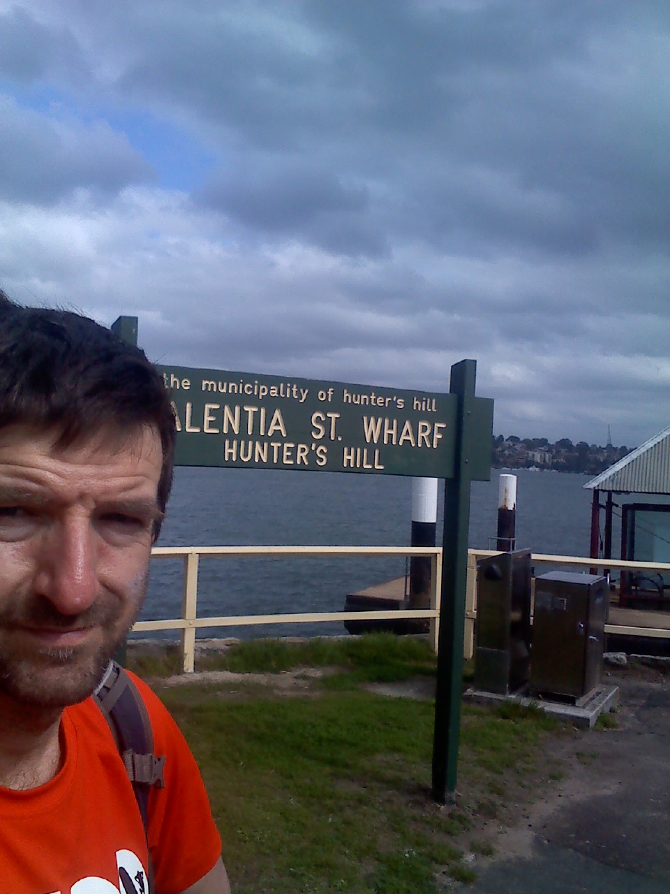
Finally I turned down the very last hill down to Valencia St Wharf at Woolwhich, which really is the end/beginning of the Great North Walk in Sydney. There is a plaque there like the one in Newcastle. The Great North Walk signs all point to “Sydney Cove”, but there’s no indication at all of the walk at Sydney Cove or at the Macquarie Place obelisk. All the same, I waited for a ferry and went to the obelisk for good measure, and because a train home form Circular Quay was convenient.
I’d done it! By Circular Quay it was 4 days plus 10 hours, so less at Woolwhich. I’d dreamt of finishing this walk, the GNW250 for years, long before I’d even heard of track racing or Centurion walking. I was delighted at the achievement, and that I’d never have to try again or have it lingering on my “to do” list. It was done!
Gear etc. for my Great North Walk
I found reading other people’s trip reports inspiring and fascinating, including what gear they used and how they did things. So, in case anyone is interested or it is helpful to anyone, here is a bit of what I used and did:
Shoes: Skechers Ultra 2 with Dirty Girl lightweight gaiters. Not a single pebble made it into my shoes for the entire walk, and hardly even any dust. The last 100km I wore a pair of white socks that were still white when I got home.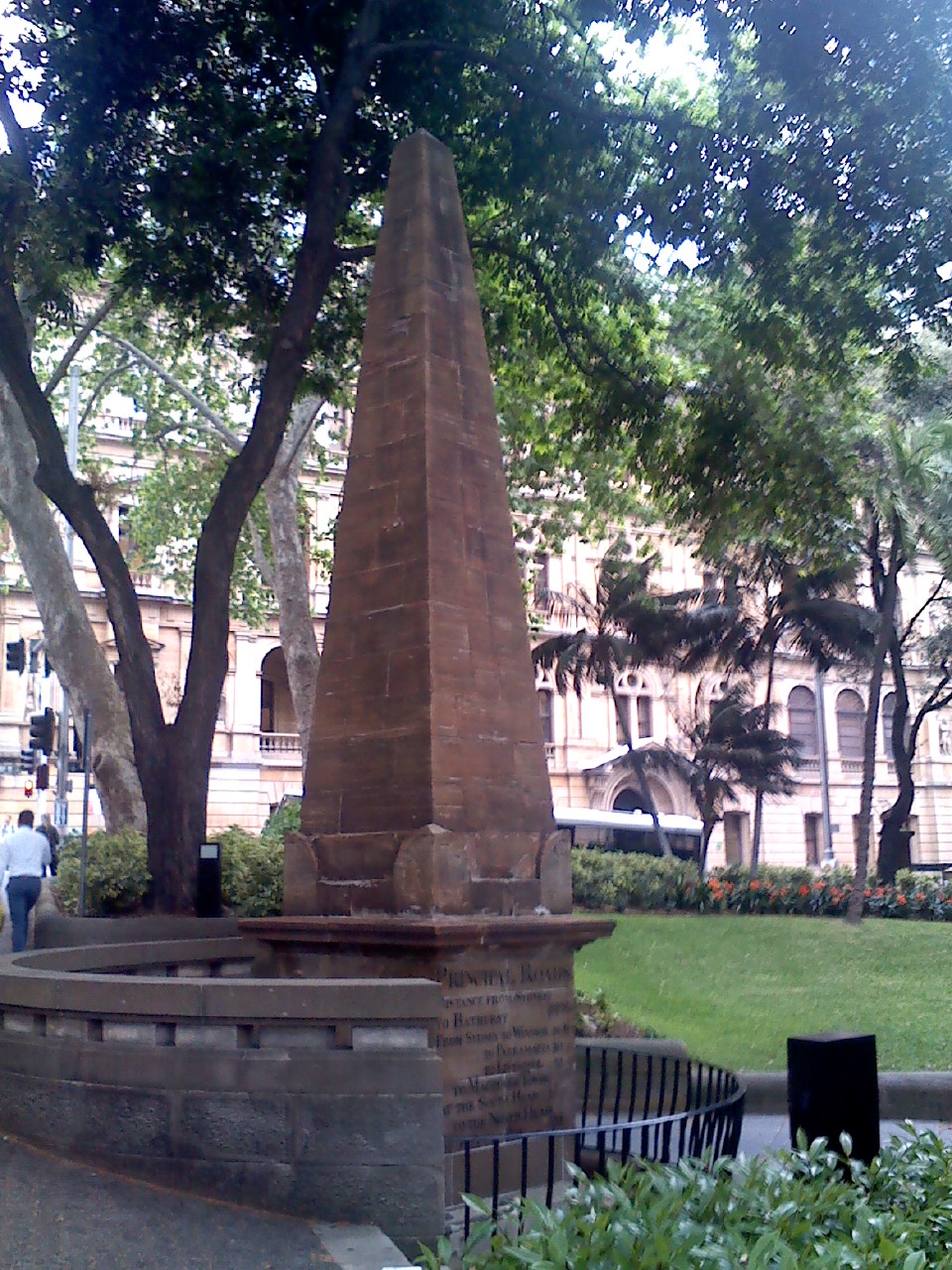
Socks: Merrell light hiking socks (legs 1 – 3) & Thorlo walking socks (leg 4). Started developing blisters in final leg, may be a coincidence.
Pack: Gregory 40L
Clothes (worn or carried): Macpac running shorts with large zip pockets, microfiber underwear, themal pants and top, sports t shirt, Rab lightweight rain jacket, Team waterproof pants, Macpac synthetic puffy-jacket (light and packs to almost nothing)
Camping Gear: Garbage bag, space blanket, light plastic drop sheet (the kind used for painting)
Food: Nuts, sultanas, Endura gels, salt stick electrolytes tablets, no doz caffeine tablets, BCAA tablets, protein recovery bar x2, flat bread, mars bar 1/day.
Other: Body Glide liquefied powder anti-chafing lube – was outstanding, no problems at all. Reapplied early and often, at the first hint of need. Chafing helped kill my previous attempt; Also aqua tabs for water purifying any more dodgy source.
I left two drop bags hidden in the bush, one at about 90km and the other at about 170km. They included water, sports drink, food, tarp, Thermarest, first aid, vitamins/supps. I only had access to one of these for an overnight stop, in the end. Everything was stored in a watertight, heavyweight screw top 25l water barrel, heavily camouflaged and hidden well away from campsites. No animals got into them and no one disturbed them. Of course, have to go back to collect them, but not hard to do.
General comments:
- Walking Newcastle to Sydney seemed, at least mentally, much easier than the other way.
- The rough Sydney sections of the Great North Walk should not be underestimated, they are draining.
- Would have been smarter to plan legs based on difficulty of the terrain rather than just a set distance.
- I had capacity to carry 4L of water, but definitely didn’t need that thanks to the new water tanks at places like Barraba Trig. The worst section is now probably Crosslands to Thornleigh, as none of the water is drinkable and there are no taps or tanks without going way off course. Cedar Brush to Yarramalong is also very dry, as all the creeks flow through rural land and there are no taps in Yarramalong (but there are at the school 300m on from the store). There are some clean creeks on Bumble Hill.
- It is very hard to keep warm with a single space blanket. Two would be much better, with hardly any weight gain. They are also waterproof and windproof and make good emergency tarps/shelters.
- In the absence of a ferry at Patonga, the Wondabyne option is recommended for Great North Walk solo walkers
Nice work, this course is a BEAST !
Hi Saul
Well written and informative article. I just completed my own solo unsupported GNW250 on Friday night (Oct 2 2015) arriving at Woolwhich Warf midnight, 45min after the last Ferry to Circular Quay.
My previous attempt at Easter Weekend I had to get picked up at Congewai after a night under a my lightweight hoochie tarp in flogging rain at Baraba Trig Camp.
I didn’t have any supply drops and I went via Patonga which was really hard in the Heat and got a lift from Patonga to Brooklyn.
I had sleep breaks in dry thermals, light fleece and water proofs wrapped up in a hoochie tarp and managed to sleep warm and well at Baraba Trig, Somersby School BBQ shelter and Cowan Train Station which gave me an appreciation of how it feels to be homeless!
Overall it took me 91hrs and I spent most of it telling myself I had to finish as I never want to have do this again!
I hope to be able to write up a report as well as I think every ones story is interesting.
Well done and thanks
Regards Ray
Hi Ray, you must have been not that far behind me. Congratulations on making it to the end. I was thinking exactly the same thing: I didn’t want to have to try it again. I found other people’s reports motivating and helpful, look forward to reading yours. Cheers, Saul.